Avon Ring
A busy two weeks taking in the Avon and Severn Rivers via Tewkesbury, with a superb mixture of scenery and interesting places to visit.
Scroll down for details
We are currently running some special offers, Click here for more info
Christmas Opening Times
The office will be closed from the 20th December until the 5th January, but you can still book your holiday online
These route suggestions are offered in good faith and to the best of our knowledge. It is up to you to decide on your own stops and to ensure you return to the base at the agreed time.
we recommend you also check for current stoppages on the CRT website that may affect your choice of route
Avon Ring
Napton to Long Itchington
Pictures: click for a bigger image

Points of Interest
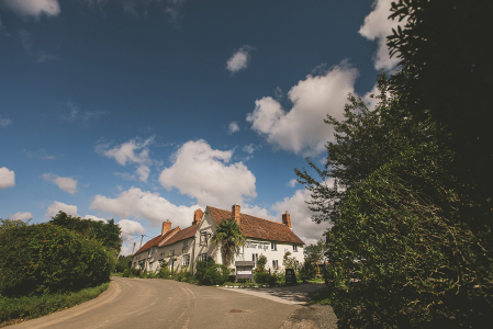
Napton-on-the-Hill
Napton-on-the-hill, the home village of Napton Narrowboats.
Pictures: click for a bigger image

Location: On Google Maps
Best Access From: Bottom of the Napton Locks, Click for Route Map.
- Postcode: CV478HX
Points of Interest in Napton-on-the-Hill
The Kings Head Napton
The Kings Head is ideally situated on the A425 between Southam and Daventry.
It is just a 5 minute walk from Napton Narrowboats
Pub dining times
Mon to Thursday 12.00 noon to 2.00pm
Mon to Thurs - eve 6.00pm to10.00pm
Fri to Sat 12.00 noon to 10.00pm
Sunday 12.00 noon to 8.00pm
Reservations highly recommended. Please call 01926 812202.
Pictures: click for a bigger image

Location: On Google Maps
Best Access From: Bridge 109, Click for Route Map.
- Postcode: CV478NG
Napton Village Stores
Including a Post Office, and offering a range of local produce. Includes a cafe.
Napton Village Stores is owned and run by a local family, acquired in January 2014, offering a friendly welcome to local regulars and visitors to the village alike. The store itself had a complete refresh and the �Napton Kitchen� was introduced � a home from home place to enjoy a hot drink and a wealth of homemade foods to eat in or take away. Our deli fridge will tempt you daily and we also offer outside catering � we can bring the Napton Kitchen to your home or office.
Pictures: click for a bigger image

Location: On Google Maps
Best Access From: Folly Lane Bridge, Click for Route Map.
- Postcode: CV478LR
Napton Cidery
Craft Cider & Perry
Napton Cidery is an award-winning, family-run craft cidery based in Warwickshire. Buy our selection of naturally vegan & gluten-free ciders & perry online. Learn more about our unique cider tour & tasting experiences, around Warwickshire, Coventry & Birmingham.
Pictures: click for a bigger image

Location: On Google Maps
Best Access From: Bottom of Napton Locks, Click for Route Map.
- Postcode: CV478NY
The Folly Pub
The Folly Inn, Napton is a family and dog friendly, warm, local pub with excellent homemade food.
Pictures: click for a bigger image

Location: On Google Maps
Best Access From: Bottom of Napton Locks, Click for Route Map.
- Postcode: CV478NZ
Boat Inn
Canalside pub & restaurant above Stockton Locks.
Food served Wednesday to Sunday
Pictures: click for a bigger image


Location: On Google Maps
Best Access From: Bridge 21, Click for Route Map.
Blue Lias pub
The Blue Lias Inn has been owned by the Stafford Family since 1984. Known for it's great beer, beautiful garden alongside the Grand Union Canal and Christmas decorations that would put Lapland to shame, the Pub is still going strong over 37 years later.
Pictures: click for a bigger image
Location: On Google Maps
Best Access From: Bridge 23, Click for Route Map.
- Postcode: CV478LD
Long Itchington
Location: On Google Maps
Best Access From: two boats public house, Click for Route Map.
Points of Interest in Long Itchington
Two Boats Pub
At The Two Boats you can enjoy a great selection of real ales, fine wines, bottled and draft beers.
Pictures: click for a bigger image
Location: On Google Maps
Best Access From: Bridge 25, Click for Route Map.
- Postcode: CV479QZ
The Cuttle Inn
Canalside pub with large garden
Pictures: click for a bigger image
Location: On Google Maps
Best Access From: Bridge 25, Click for Route Map.
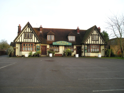
Duck on The Pond
Pub & Restaurant in Long Itchington.
'Cinnamon Arch' also offer their delicious Indian food at the Duck on the Pond, to dine in as well as takeaways.
Pictures: click for a bigger image
Location: On Google Maps
Best Access From: Bridge 25 - 1/2 mile walk, Click for Route Map.
Buck and Bell Pub
A Family friendly village pub offering a warm welcome a wide selection of drinks
Pictures: click for a bigger image

Location: On Google Maps
Best Access From: Bridge 25 - 1/2 mile walk, Click for Route Map.
Harvester Pub
Village inn serving real ales and pub grub including locally sourced steaks in its small restaurant.
Location: On Google Maps
Best Access From: Bridge 25 - 1/2 mile walk, Click for Route Map.
Green Man Pub
Pub in Long Itchington
Pictures: click for a bigger image

Location: On Google Maps
Best Access From: Bridge 26A, Click for Route Map.
- Postcode: CV479PW
Holy Trinity Church, Long Itchington
Location: On Google Maps
Best Access From: Bridge 25/26/26A, Click for Route Map.
- Postcode: CV47 9FN
Co op Shop
Village shop for food & drink
Location: On Google Maps
Best Access From: Bridge 25, Click for Route Map.
Long Itchington to Warwick
Points of Interest
Radford Semele
A short walk from the Canal, this village makes a nice stop off for the night.
Location: On Google Maps
Best Access From: Bridge 34, Click for Route Map.
Points of Interest in Radford Semele
The White Lion Pub
The White Lion is a smart, historic country pub in the village of Radford Semele
Pictures: click for a bigger image

Location: On Google Maps
Best Access From: Bridge 34, Click for Route Map.
- Postcode: CV311TE
Best One Convenience Store
29-31 Lewis Rd, Radford Semele, Semele
Location: On Google Maps
Best Access From: Bridge 34, Click for Route Map.
- Postcode: CV311UQ
Sydenham
Location: On Google Maps
Best Access From: Bridge 27, Click for Route Map.
Points of Interest in Sydenham
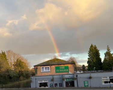
The Fusilier Pub
"A local pub like no other". The Fusilier is a fantastic traditional pub situated right at the heart of the local Sydenham community in Leamington Spa.
Pictures: click for a bigger image
Location: On Google Maps
Best Access From: Bridge 37, Click for Route Map.
- Postcode: CV311NJ
Sydenham Shops & Takeaway
A Small cluster of Takeaways & a convenience store & post office within a stone's throw of the canal. Chinese, Indian, and Fish & Chips
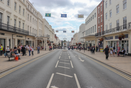
Royal Leamington Spa
Royal Leamington Spa is a beautiful town located in the heart of Warwickshire.
Pictures: click for a bigger image
Location: On Google Maps
Best Access From: Bridge 40, Click for Route Map.
Points of Interest in Royal Leamington Spa
Pharmacy
Location: On Google Maps
Best Access From: Bridge 40, Click for Route Map.
Morrisons
Large supermarket a short walk from the canal
Location: On Google Maps
Best Access From: Towpath moorings outside, Click for Route Map.
Sainsburys, Leamington
Large Supermarket
Location: On Google Maps
Best Access From: Bridge 43, Click for Route Map.
Lidl, Leamington
Canalside supermarket
Location: On Google Maps
Best Access From: Canalside from Towpath, Click for Route Map.
The Moorings at Myton
Stylishly revamped pub by the canal, with real ales and a Modern British menu, plus outside tables.
Pictures: click for a bigger image

Location: On Google Maps
Best Access From: Bridge 43, Click for Route Map.
- Postcode: CV313NY
Co op, Leamington
Location: On Google Maps
Best Access From: Bridge 40, Click for Route Map.
- Postcode: CV312DP
Tesco - Warwick
Supermarket near the canal
Location: On Google Maps
Best Access From: Bridge 46, Click for Route Map.
Sainsburys, Warwick
Location: On Google Maps
Best Access From: Bridge 51, Click for Route Map.
Cape of Good Hope pub
Pictures: click for a bigger image

Location: On Google Maps
Best Access From: Cape Moorings, Click for Route Map.
Warwick to Rowington
Points of Interest
Hatton Locks
A flight of 21 locks spread over less than 2 miles. One of the well known historical features of the canal system, often known as the "Stairway to Heaven"
Pictures: click for a bigger image

Location: On Google Maps
Best Access From: Towpath, Click for Route Map.
The Hatton Arms
A dog-friendly historic 18th-century pub, an old coaching inn, overlooks the Hatton locks with amazing views from the spacious beer garden and outdoor dining terrace.
Inside, you�ll find cosy corners with a warm fire in winter, and larger spaces perfect for special occasions.
Pictures: click for a bigger image

Location: On Google Maps
Best Access From: Footpath from canal bridge 4 locks down, Click for Route Map.
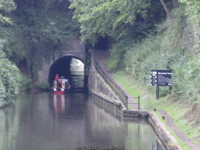
Shrewley Tunnel
Canal tunnel under Shrewley village, unusual in having one tunnel for the boat, and a separate, higher tunnel for the horse!
Pictures: click for a bigger image
Location: On Google Maps
Best Access From: The Canal!, Click for Route Map.
Tom O' The Wood, Rowington
A country pub located in the picturesque village of Rowington alongside the Grand Union canal.
This stunning pub run by Chris & Charlie, has a passion for serving good, fresh, homemade food, which is locally sourced from local suppliers & farms.
Tom O� The Wood is a dog friendly pub, that caters for all.
Pictures: click for a bigger image

Location: On Google Maps
Best Access From: Bridge 63, Click for Route Map.
Rowington to Wootton Wawen
Points of Interest
Kingswood Junction
The junction of the Grand Union and Stratford-upon-Avon canals. Turn south here for Stratford. 9 more locks (single this time) will take you to Lowsonford
Location: On Google Maps
Best Access From: The Canal!, Click for Route Map.
Lowsonford
A small village in Warwickshire, home to the Fleur de Lys pub, making a nice nightime stop.
Location: On Google Maps
Points of Interest in Lowsonford
Fleur de Lys Pub
This quaint, white-washed rustic, oak-beamed inn has an open fire and a peaceful, canalside garden. Dog friendly, family friendly & famous for its award-winning pies.
Pictures: click for a bigger image
Location: On Google Maps
Best Access From: 'New Road' bridge, Click for Route Map.
Wootton Wawen
A village in mid-western Warwickshire, about 20 miles (32 km) from Birmingham and about 6.5 miles (10 km) north of Stratford-upon-Avon. The older part of the village straddling the A3400 is designated as a Conservation Area because of its open, rural character and many historic buildings.
Location: On Google Maps
Best Access From: Wootton Wawen Aqueduct, Click for Route Map.
Points of Interest in Wootton Wawen
The Navigation Inn
A canalside pub in Wootton Wawen, serving great food with stunning waterside views
The General Store, Wootton Wawen
Handy shop 10 minutes walk from the canal, open every day.
Location: On Google Maps
Best Access From: Wootton Wawen Aqueduct, Click for Route Map.
The Bull's Head, Wootton Wawen
Exquisite, authentic Thai cuisine & the service you deserve, in a delightful, old-world heritage pub.
With great ales, drafts, crafts & wine, as well as some of your Great British pub grub favourites.
Online booking available
Pictures: click for a bigger image

Location: On Google Maps
Best Access From: Wootton Wawen Aqueduct, Click for Route Map.
Wootton Wawen to Stratford-upon-Avon
Points of Interest
Edstone Aqueduct
At 475 feet (145 m), Edstone is the longest cast iron aqueduct in England. The towpath is set level with the base of the trough, which is a somewhat unusual design feature and makes for an interesting viewpoint of the boats crossing the valley.
,
Pictures: click for a bigger image

Location: On Google Maps
Best Access From: Boating over the top of it.., Click for Route Map.
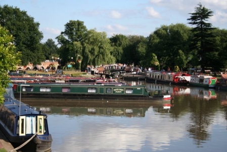
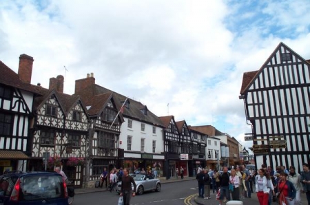
Stratford-Upon-Avon
The town is a popular tourist destination owing to its status as birthplace of the playwright and poet William Shakespeare. The Royal Shakespeare Company resides in Stratford's Royal Shakespeare Theatre, one of Britain's most important cultural venues.
There are lots of shops, pubs, restaurants and takeaways in town.
Pictures: click for a bigger image


Location: On Google Maps
Best Access From: Bancroft Basin, Click for Route Map.
- What3Words: letter/gather/raced
Points of Interest in Stratford-Upon-Avon
Shakespeare's Birthplace
Half-timbered shrine to the Bard, with memorabilia, period furnishings and changing exhibitions.
Location: On Google Maps
Best Access From: Bancroft Basin, Click for Route Map.
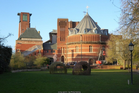
Royal Shakespeare Theatre
The main venue in Stratford-upon-Avon for the performance of Shakespeare's (an other's) plays. Home of the Royal Shakespeare Company.
Pictures: click for a bigger image
Location: On Google Maps
Best Access From: Bancroft Basin, Click for Route Map.
Stratford-upon-Avon to Evesham
Points of Interest
Evesham
A market town Worcestershire, founded around an 8th Century Abbey
Location: On Google Maps
Points of Interest in Evesham
Fairfield Fish Bar
Family run fish and chip shop
Location: On Google Maps
Best Access From: Evesham Bridge, Click for Route Map.
Taste of Gurkha
Nepalese Restaurant and Takeaway, close to the river
Location: On Google Maps
Best Access From: Workman Bridge, Click for Route Map.
The Red Lion, Evesham
A traditional, friendly, real ale & cider pub with regular live music in the heart of Evesham.
We do not have a TV, fruit or quiz machines, 'piped' / pre-recorded music, jukebox or other distractions. We do, however, have a cozy atmosphere, great beers, regular live music and a warm welcome
Pictures: click for a bigger image

Location: On Google Maps
Best Access From: Workman Bridge, Click for Route Map.
Monica's Fish Bar & Cafe
It has always been our aim here at Monica's Fish Bar & Cafe to offer the best Fish & Chips you can find as well as heaps of other great tasting meals.
Location: On Google Maps
Best Access From: Workman Bridge, Click for Route Map.
The Old Swan Inne
A Wetherspoon's Chain pub
Pictures: click for a bigger image

Location: On Google Maps
Best Access From: Workman Bridge, Click for Route Map.
Evesham to Tewkesbury.
Points of Interest
Tewkesbury
The confluence of the Avon & Severn rivers, this is the lower limit of navigation on the Avon. The market town is medieval in origin and sits in the county of Gloucestershire.
Visitor moorings are above & below Avon Lock, just downstream from King John's Bridge.
Location: On Google Maps
Best Access From: King John's Bridge, Click for Route Map.
Points of Interest in Tewkesbury
Kingfisher Fish & Chips
Traditional chip shop. We serve everything you expect from your local chip shop offering you & your family great value for money. Our online ordering system allows you to order ahead with ease, click and collect and beat the queue.
Pictures: click for a bigger image

Location: On Google Maps
Best Access From: Quay Street Bridge, Click for Route Map.
The Black Bear, Tewkesbury
Established in 1308, The Black Bear in Tewkesbury is the oldest pub in Gloucestershire. This timber-framed medieval pub offers a cosy atmosphere with traditional pub meals and real ales. Restored with care, it combines centuries of character with today�s welcoming hospitality in the Severn Vale.
Pictures: click for a bigger image

Location: On Google Maps
Best Access From: King John's Bridge, Click for Route Map.
The Albion Inn, Tewkesbury
Traditional community pub, part of the Proper Pub chain.
Pictures: click for a bigger image

Location: On Google Maps
Best Access From: King John's Bridge, Click for Route Map.
The Great Wall Chinese Restaurant & Takeaway
Location: On Google Maps
Best Access From: Quay Street Bridge, Click for Route Map.
Tesco Express, Tewkesbury
Handy for stocking up on provisions
Location: On Google Maps
Best Access From: King John's Bridge, Click for Route Map.
Zitto e Mangia Italian Restaurant
Freshly prepared cuisine by talented Italian chefs. Takeaway also available
Pictures: click for a bigger image

Location: On Google Maps
Best Access From: Quay Street Bridge, Click for Route Map.
Tewkesbury to Worcester
Points of Interest
Upton-Upon-Severn
A small riverside side town, this can make a handy stop for provisions or lunch from one of the nearby establishments.
Location: On Google Maps
Best Access From: Pontoon visitor moorings, Click for Route Map.
Points of Interest in Upton-Upon-Severn
The Plough Inn
Dog friendly Marston's chain pub next to the river
Pictures: click for a bigger image

Location: On Google Maps
Best Access From: Pontoon visitor moorings, Click for Route Map.
Ye Olde Anchor Inn
At Ye Olde Anchor Inn we are a Traditional "Black & White", timber framed Pub set in the Historical Riverside Town of Upton upon Severn, parts of the pubs building have been on this site since circa 1601. We serve Excellent Ales, Ciders, and Lagers and have a Full Wine List. Great food is served seven days a week
Pictures: click for a bigger image

Location: On Google Maps
Best Access From: Pontoon visitor moorings, Click for Route Map.
Boot Pharmacy, Upton-upon-Severn
handy pharmacy close to the river
Location: On Google Maps
Warner's Supermarket
Independent supermarket with a good mix of brand products and local produce
Location: On Google Maps
Best Access From: Pontoon visitor moorings, Click for Route Map.
Worcester (Commandery Visitor Moorings)
2-day moorings in the heart of Worcester City.
There are far too many pubs, restaurants, cafes, shops, museums etc. to list more than a handful here. We suggest you click the Google Map link, and Zoom in to browse what's available in this city.
Location: On Google Maps
Points of Interest in Worcester (Commandery Visitor Moorings)
Ye Olde Talbot
Located opposite the majestic Worcester Cathedral, Ye Olde Talbot hotel is a traditional coaching inn dating from the 13th century. The bar offers a seasonal menu, alongside wines and real ales.
Pictures: click for a bigger image

Location: On Google Maps
Best Access From: Commandery Moorings, Click for Route Map.
The King's head, Worcester
Canalside pub serving great beer and great food, conveniently close to the Commandery moorings
Pictures: click for a bigger image

Location: On Google Maps
Best Access From: Commandery Moorings, Click for Route Map.
Worcester Cathedral
Norman-era, Gothic place of CofE worship containing the tomb of King John and a 235-step tower.
Pictures: click for a bigger image

Location: On Google Maps
Best Access From: Commandery Moorings, Click for Route Map.
Asda Superstore, Worcester
Large chain supermarket, for all your provisions.
Location: On Google Maps
Best Access From: Commandery Moorings, Click for Route Map.
Mother Hubbard's Famous Fish & Chips (Worcester)
Fish & Chips are loved by every generation. Are you looking for crispy batter on the tastiest fish, succulent chips & perfect mushy peas?
Look no further than Mother Hubbard's & indulge in the finest traditional fish & chips in the area.
Eat in or take away
Location: On Google Maps
Best Access From: Along the Canal Towpath!, Click for Route Map.
Worcester to Stoke Pound
Points of Interest
Lidl, Worcester
Large chain supermarket, 10 minutes walk from the canal
Location: On Google Maps
Best Access From: Blackpole Bridge (19), Click for Route Map.
Barn Owl Pub
A Marston's pub built from a converted barn, with beer garden & children's play area. Dogs Welcome.
Location: On Google Maps
Best Access From: Tolladine Bridge (22), Click for Route Map.
The Bridge at Tibberton
Canalside pub & dining. Two large gardens with one having great views of the canal, having a varied selection of firm pub favourite meals with a good selection on the specials board to suit all tastes.
Pictures: click for a bigger image

Location: On Google Maps
Best Access From: Tibberton Bridge (25), Click for Route Map.
Speed the Plough
Village pub in Tibberton with a beer garden.
Pictures: click for a bigger image

Location: On Google Maps
Best Access From: Tolladine Bridge (22), Click for Route Map.
Eagle & Sun
Waterside pub-restaurant with an airy hall, banquettes with cushions, pub grub and a beer garden.
Pictures: click for a bigger image

Location: On Google Maps
Best Access From: Hanbury visitor moorings, Click for Route Map.
The Queens Head
Canalside pub with contemporary decor mixed with original features, live music and food including wood-fired pizzas. Large beer garden
Pictures: click for a bigger image

Location: On Google Maps
Best Access From: Towpath Moorings, Click for Route Map.
Boat & Railway
Dog friendly Marston's chain pub & restaurant.
Pictures: click for a bigger image

Location: On Google Maps
Best Access From: Stoke Works visitor moorings, Click for Route Map.
The Navigation Inn, Bromsgrove
Pub serving food & takeaways
Pictures: click for a bigger image

Location: On Google Maps
Best Access From: Stoke Wharf, Click for Route Map.
Stoke Pound to Alvechurch
Points of Interest
Tardebigge Lock Flight
Tardebigge Locks or the Tardebigge Flight is the longest flight of locks in the UK, comprising 30 narrow locks on a two-and-a-quarter-mile (3.6 km) stretch of the Worcester and Birmingham Canal at Tardebigge, Worcestershire. It raises the waterway 220 feet (67 m)
Location: On Google Maps
The Tardebigge Pub
15 minute walk from Tardebigge Top Lock. Once part of the Earl of Plymouth�s estate, The Tardebigge houses a restaurant, bar area, large beer garden with a heated covered area and two private rooms.
Pictures: click for a bigger image

Location: On Google Maps
Best Access From: Moorings between Tardebigge top lock & Tunnel, Click for Route Map.
Alvechurch
A large village in the Bromsgrove district of North-Eastern Worcestershire.
Location: On Google Maps
Best Access From: Withybed Lane Bridge (61), Click for Route Map.
Points of Interest in Alvechurch
The Weighbridge Inn, Alvechurch
Real ales and pub grub in a snug, simple canalside inn with vintage photos, plus beer garden/patio. It won "Branch pub of the year 2024" from CAMRA
Pictures: click for a bigger image

Location: On Google Maps
Best Access From: Scarfield Hill Bridge (60), Click for Route Map.
The Crown Inn, Alvechurch
A newly refurbished country pub, boasting an idyllic spot surrounded by rolling countryside and situated next to the Worcester and Birmingham canal, all this can be enjoyed relaxing in our beer garden or extensive rear patio.
Pictures: click for a bigger image

Location: On Google Maps
Best Access From: Withybed Lane Bridge (61), Click for Route Map.
The Tudor Rose Fish Bar
Fish & Chip shop in Alvechurch, 3/4 miles from the canal.
Location: On Google Maps
Best Access From: Withybed Lane Bridge (61), Click for Route Map.
The Swan Inn, Alvechurch
A community pub serving a great range of Beers, Ales, Wines & Spirits. Doesn't Serve Food.
Pictures: click for a bigger image

Location: On Google Maps
Best Access From: Withybed Lane Bridge (61), Click for Route Map.
The Red Lion, Alvechurch
Smart village pub and restaurant with an updated pub-style menu, cask ales and a beer garden.
Pictures: click for a bigger image

Location: On Google Maps
Best Access From: Withybed Lane Bridge (61), Click for Route Map.
New Dilshad Indian Restaurant and Takeaway
A contemporary Indian restaurant, where you can enjoy the taste of authentic Indian cuisine. We have a wide variety of dish�s to choose from, ranging from traditional dishes to exciting new additions.
Location: On Google Maps
Best Access From: Withybed Lane Bridge (61), Click for Route Map.
Alvechurch to Hockley Heath
Points of Interest
Lidl, King's Heath
Large supermarket just a short walk from the canal
Location: On Google Maps
Best Access From: Canal Towpath , Click for Route Map.
The Horseshoe Pub
Old School Canalside pub
Pictures: click for a bigger image

Location: On Google Maps
Best Access From: Canal Towpath, Click for Route Map.
Drawbridge Inn
Canalside pub by the lift bridge in Shirley
Location: On Google Maps
Best Access From: Canalside moorings, Click for Route Map.
- Postcode: B901DD
Blue Bell Cider house
The Bluebell Cider House Earlswood, a lively and much-loved countryside pub known for great food, real ales, ciders, and a welcoming atmosphere.
Pictures: click for a bigger image

Location: On Google Maps
Best Access From: Canal Towpath, Click for Route Map.
The Wharf Tavern, Hockley Heath
The Wharf Tavern in Solihull is a charming canal-side pub, offering the cosy feel of a local country escape. Known for its hearty, home-cooked meals and friendly atmosphere, it's the perfect place to relax by the water with friends and family.
Pictures: click for a bigger image

Location: On Google Maps
Best Access From: Canal Towpath, Click for Route Map.
Nelson's Fish & Chips, Hockley Heath
As well as the traditional fare of fish and chips we also provide great tasting chicken and lamb doner kebabs, burgers, pies and more, a fantastic menu to for all tastes.
Location: On Google Maps
Best Access From: Canal Towpath, Click for Route Map.
Co-op, Hockley Heath
Convenience store close to the canal
Location: On Google Maps
Best Access From: Canal Towpath, Click for Route Map.
Hockley Heath to Hatton Top Lock
Points of Interest
Lapworth Locks
A flight of 19 narrow locks takes you from the Grand Union Canal at Kingswood Junction up the Northern Stratford Canal.
Location: On Google Maps
Best Access From: The Canal, Click for Route Map.
Kingswood Junction
The junction of the Grand Union and Stratford-upon-Avon canals. Turn south here for Stratford. 9 more locks (single this time) will take you to Lowsonford
Location: On Google Maps
Best Access From: The Canal!, Click for Route Map.
Tom O' The Wood, Rowington
A country pub located in the picturesque village of Rowington alongside the Grand Union canal.
This stunning pub run by Chris & Charlie, has a passion for serving good, fresh, homemade food, which is locally sourced from local suppliers & farms.
Tom O� The Wood is a dog friendly pub, that caters for all.
Pictures: click for a bigger image
Location: On Google Maps
Best Access From: Bridge 63, Click for Route Map.
Shrewley Tunnel
Canal tunnel under Shrewley village, unusual in having one tunnel for the boat, and a separate, higher tunnel for the horse!
Pictures: click for a bigger image
Location: On Google Maps
Best Access From: The Canal!, Click for Route Map.
The Hatton Arms
A dog-friendly historic 18th-century pub, an old coaching inn, overlooks the Hatton locks with amazing views from the spacious beer garden and outdoor dining terrace.
Inside, you�ll find cosy corners with a warm fire in winter, and larger spaces perfect for special occasions.
Pictures: click for a bigger image
Location: On Google Maps
Best Access From: Footpath from canal bridge 4 locks down, Click for Route Map.
Hatton Top Lock to Radford Semele
Points of Interest
Hatton Locks
A flight of 21 locks spread over less than 2 miles. One of the well known historical features of the canal system, often known as the "Stairway to Heaven"
Pictures: click for a bigger image
Location: On Google Maps
Best Access From: Towpath, Click for Route Map.
Cape of Good Hope pub
Pictures: click for a bigger image
Location: On Google Maps
Best Access From: Cape Moorings, Click for Route Map.
Royal Leamington Spa
Royal Leamington Spa is a beautiful town located in the heart of Warwickshire.
Pictures: click for a bigger image
Location: On Google Maps
Best Access From: Bridge 40, Click for Route Map.
Points of Interest in Royal Leamington Spa
Pharmacy
Location: On Google Maps
Best Access From: Bridge 40, Click for Route Map.
Morrisons
Large supermarket a short walk from the canal
Location: On Google Maps
Best Access From: Towpath moorings outside, Click for Route Map.
Sainsburys, Leamington
Large Supermarket
Location: On Google Maps
Best Access From: Bridge 43, Click for Route Map.
Lidl, Leamington
Canalside supermarket
Location: On Google Maps
Best Access From: Canalside from Towpath, Click for Route Map.
The Moorings at Myton
Stylishly revamped pub by the canal, with real ales and a Modern British menu, plus outside tables.
Pictures: click for a bigger image
Location: On Google Maps
Best Access From: Bridge 43, Click for Route Map.
- Postcode: CV313NY
Co op, Leamington
Location: On Google Maps
Best Access From: Bridge 40, Click for Route Map.
- Postcode: CV312DP
Sydenham
Location: On Google Maps
Best Access From: Bridge 27, Click for Route Map.
Points of Interest in Sydenham
The Fusilier Pub
"A local pub like no other". The Fusilier is a fantastic traditional pub situated right at the heart of the local Sydenham community in Leamington Spa.
Pictures: click for a bigger image
Location: On Google Maps
Best Access From: Bridge 37, Click for Route Map.
- Postcode: CV311NJ
Sydenham Shops & Takeaway
A Small cluster of Takeaways & a convenience store & post office within a stone's throw of the canal. Chinese, Indian, and Fish & Chips
Radford Semele
A short walk from the Canal, this village makes a nice stop off for the night.
Location: On Google Maps
Best Access From: Bridge 34, Click for Route Map.
Points of Interest in Radford Semele
The White Lion Pub
The White Lion is a smart, historic country pub in the village of Radford Semele
Pictures: click for a bigger image
Location: On Google Maps
Best Access From: Bridge 34, Click for Route Map.
- Postcode: CV311TE
Best One Convenience Store
29-31 Lewis Rd, Radford Semele, Semele
Location: On Google Maps
Best Access From: Bridge 34, Click for Route Map.
- Postcode: CV311UQ
Radford Semele to Calcutt Locks
Points of Interest
Long Itchington
Location: On Google Maps
Best Access From: two boats public house, Click for Route Map.
Points of Interest in Long Itchington
Two Boats Pub
At The Two Boats you can enjoy a great selection of real ales, fine wines, bottled and draft beers.
Pictures: click for a bigger image
Location: On Google Maps
Best Access From: Bridge 25, Click for Route Map.
- Postcode: CV479QZ
The Cuttle Inn
Canalside pub with large garden
Pictures: click for a bigger image
Location: On Google Maps
Best Access From: Bridge 25, Click for Route Map.
Duck on The Pond
Pub & Restaurant in Long Itchington.
'Cinnamon Arch' also offer their delicious Indian food at the Duck on the Pond, to dine in as well as takeaways.
Pictures: click for a bigger image
Location: On Google Maps
Best Access From: Bridge 25 - 1/2 mile walk, Click for Route Map.
Buck and Bell Pub
A Family friendly village pub offering a warm welcome a wide selection of drinks
Pictures: click for a bigger image
Location: On Google Maps
Best Access From: Bridge 25 - 1/2 mile walk, Click for Route Map.
Harvester Pub
Village inn serving real ales and pub grub including locally sourced steaks in its small restaurant.
Location: On Google Maps
Best Access From: Bridge 25 - 1/2 mile walk, Click for Route Map.
Green Man Pub
Pub in Long Itchington
Pictures: click for a bigger image
Location: On Google Maps
Best Access From: Bridge 26A, Click for Route Map.
- Postcode: CV479PW
Holy Trinity Church, Long Itchington
Location: On Google Maps
Best Access From: Bridge 25/26/26A, Click for Route Map.
- Postcode: CV47 9FN
Co op Shop
Village shop for food & drink
Location: On Google Maps
Best Access From: Bridge 25, Click for Route Map.
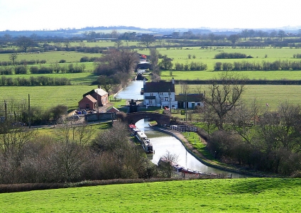
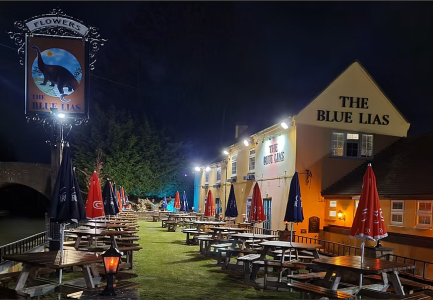
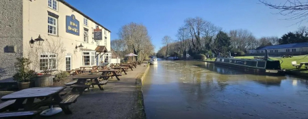
Blue Lias pub
The Blue Lias Inn has been owned by the Stafford Family since 1984. Known for it's great beer, beautiful garden alongside the Grand Union Canal and Christmas decorations that would put Lapland to shame, the Pub is still going strong over 37 years later.
Pictures: click for a bigger image
Location: On Google Maps
Best Access From: Bridge 23, Click for Route Map.
- Postcode: CV478LD
Boat Inn
Canalside pub & restaurant above Stockton Locks.
Food served Wednesday to Sunday
Pictures: click for a bigger image
Location: On Google Maps
Best Access From: Bridge 21, Click for Route Map.
The Kings Head Napton
The Kings Head is ideally situated on the A425 between Southam and Daventry.
It is just a 5 minute walk from Napton Narrowboats
Pub dining times
Mon to Thursday 12.00 noon to 2.00pm
Mon to Thurs - eve 6.00pm to10.00pm
Fri to Sat 12.00 noon to 10.00pm
Sunday 12.00 noon to 8.00pm
Reservations highly recommended. Please call 01926 812202.
Pictures: click for a bigger image
Location: On Google Maps
Best Access From: Bridge 109, Click for Route Map.
- Postcode: CV478NG
(add an hour[ish] if mooring overnight at Napton Marina)
Calcutt Locks to Napton Marina
Guidebooks / Maps

Pearson's Guide: Severn & Avon, Mid-Worcestershire Companion
Includes the River Avon from Tewkesbury to Stratford; the Stratford-on-Avon Canal; the Worcester & Birmingham Canal; the Droitwich Canals; the River Severn from Stourport to Gloucester; the Gloucester & Sharpness Canal; the Cotswold Canals from Framilode to Lechlade; and the Grand Union Canal between Birmingham and Braunston
Contact Us
- Phone:
- +44 (0)1926 813644 (Calls may be recorded for monitoring purposes)
- Email:
- enquiries@napton-marina.co.uk
- Open:
- November to March - 8:30am to 5:00pm (GMT) - Monday to Friday.